@Ser9ei999 thanks for reporting them scheduled for deletion!
1 Like
More of these:
iFzczItqsNmmqLo6SAzC5A
ReZF3x9lo3JdclKRDA0ZbQ
5nqg1ehyjix10atv5diw6b
vf0xyhx610oiq6fqj5hliq
92th20a4l2o1b6nxtv65ff
WgLXn5cG4ONpEkr52bHbgw
xsst7n845rkoaz3dwyudar
v4ixnxsms63gi8dowc51s4
96mqbncq57p1hr1beao9ye
wdxmsu5i8ny7hce2q35g19
Gud_ShGdfHkliHqqi3AzxQ
Thanks @Ser9ei999 scheduled for deletion!
Thanks @gitne for flagging this out. Currently we have a deletion backlog and we’re catching up with deletions.
Yes, you’re right we should act quicker on blur requests and I’ll bring this up to the team.
1 Like
Thanks for the update @GITNE, I’ll follow up blur request here once I’ll hear back more from our engineering team.
More sequences with discrete photos:
WHPlwgjwPis6ty6xNkYEyQ
YvtR1o0U5E1DYz9PnxQVaA
sthhevo4eha9b5grxv0pww
I think these were accidentally uploaded by the user:
pfv47qucfnopaazrgrpg3d
ghszzhzhwh2y4ufnv9j2ky
pfv47qucfnopaazrgrpg3d
4u9rrbme10vac5x245u5tj
07d9ckz8ypt8tl8plgl7e8
lbg8rcwl9xxbue19mxf94o
08ekzzehjckyoy75a29sko
b1mobhya0ph8h64pe9ymbf
8w7ay9nct6lv8ej6aoky9j
rzfg5jms5p1ekx070a5h84
7ogd57esweayonraaybui8
vstpz4ib35hxblckjudspe
06m43wqh90x2x6apip2mef
lvon62bugv4on10wjoz8ht
wg7m0qufcb21yweyq2002z
6gcqg4lz4a0mopucxk7h8r
ygprlahkx5fi9lw3l6q0me
o0ot8dij0hp6mhz0llkgpl
n1geloozasbg3baq43mto1_v00
By comparison, I think this is the (only?) sequence the user wanted to upload to Mapillary:
80padj3oeekaoidg48tm3j
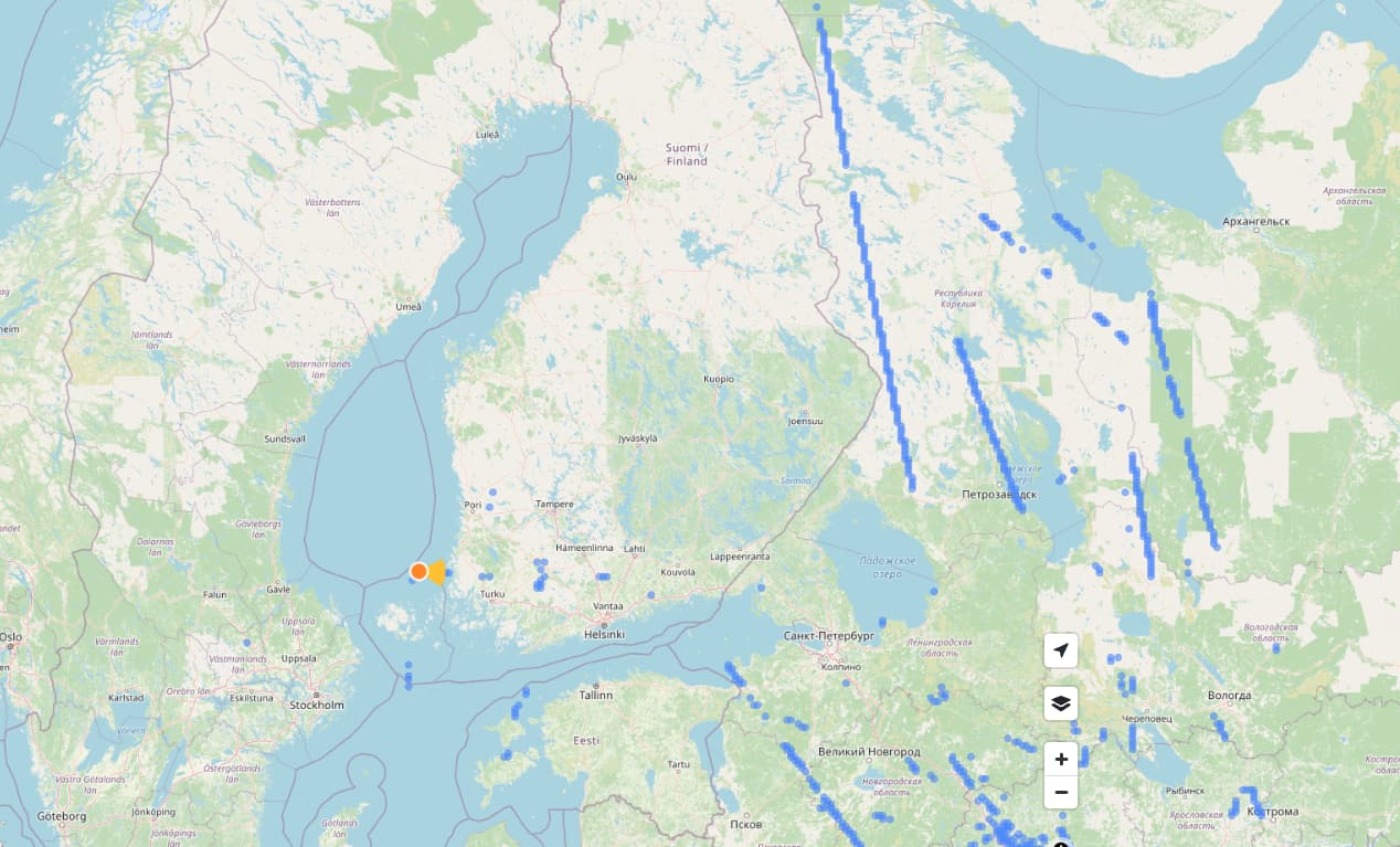
If you wanted to clean up you could start with browsing the oceans and picking up all the random green dots there. All these WSP pictures are still there or have reappeared since your starting post in this thread.
There are also a couple of peculiar images. Just east of the coast of Madagascar there is almost complete road coverage of the centre of the Brazilan town of Arapongas. Strangely flipped along a North/South axis.
I accidentally uploaded images as non-tracks, username ntzm, all bad images are on Aug 9, 2022
Incorrect GPS.
ijjbt1h0YEafhyezwmmMKg
qDmu1AZ_8HHpu8fDUpKdEg
XfPwJ6Fqh7aN6yghkgjW7w
u1M2hlq-PJ_jSwsHv2aepw
I had a script error and an entire day’s upload is offset. Is there any way to delete these so I can correct them? Uploads from September 18, 2022 , user miken
thanks,
@asturksever, Here are just a few of the sequences I found. There’s a bunch of inaccurate sequences, many of them with only one photo
From the generic username ‘phoneuploader for mobile_team’:
agv63og2q0tx1695wz49gq_v00
zk9gqu9aaoyezhilgj41n8_v00
l3mbnu8yggxqv45khron36_v00
wes1kaoh2onfi9jftsbn2g_v00
xkkitgag3kp3bfn7kt6ual_v00
qrg6ommxd1ao8e6ebgjvn0_v00
As can be seen in this screenshot, the majority of the sequences are just incorrect straight lines (strangely, photos of keyboards and people’s kitchen tables)
@GITNE Thanks for bringing this up, your sequences should be deleted shortly.
We’re automating deletion approval and if the request is done by owner of the image, it will be automatically deleted. I’ll keep you posted on this thread once it is ready!
2 Likes
Hello,
Recent polluter here, but I don’t want to be. I’ve just discovered a bug in my Novatek 96663 based camera systems that appears to, in error, trim one or sometimes a couple pages of GPS longitude by a single digit when starting a new video segment while recording.
It can be seen in the extracted GPX:
<trkpt lat="42.8316162109375" lon="-83.5615397135417">
  <time>2020-12-05T05:32:24Z</time>
</trkpt>
<trkpt lat="42.8318440755208" lon="-3.56156819661458">
  <time>2020-12-05T05:32:25Z</time>
</trkpt>
<trkpt lat="42.8320719401042" lon="-83.5615885416667">
  <time>2020-12-05T05:32:26Z</time>
</trkpt>
That can be traced back to the original GPS pages:
GPS Date/Time                   : 2020:12:05 05:32:24Z
GPS Latitude                    : 42 deg 49' 53.82" N
GPS Longitude                   : 83 deg 33' 41.54" W
GPS Speed                       : 90.5813
GPS Speed Ref                   : km/h
GPS Track                       : 353.73
GPS Track Ref                   : True North
GPS Date/Time                   : 2020:12:05 05:32:25Z
GPS Latitude                    : 42 deg 49' 54.64" N
GPS Longitude                   : 3 deg 33' 41.65" W
GPS Speed                       : 90.8962
GPS Speed Ref                   : km/h
GPS Track                       : 355.77
GPS Track Ref                   : True North
GPS Date/Time                   : 2020:12:05 05:32:26Z
GPS Latitude                    : 42 deg 49' 55.46" N
GPS Longitude                   : 83 deg 33' 41.72" W
GPS Speed                       : 90.5258
GPS Speed Ref                   : km/h
GPS Track                       : 357.42
GPS Track Ref                   : True North
Which can actually be seen imprinted on the original image by the camera:
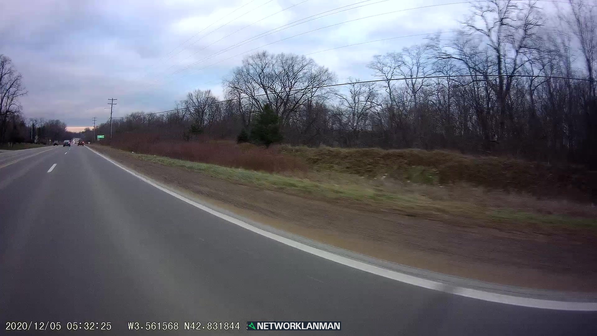
So, those singular images, then get split from the sequence because they of course, trigger the cutoff distance and interpolation does what interpolation does, then stringing a few images between those two GPS points across the map.
I know we can tell Mapillary to ignore images that are too close, but I haven’t found a way yet to tell it to discard images that are too far- at least not programmatically.
It appears the bug in my cameras is just trimming the first digit when it pleases and I’m currently trying to build a script that can find those shortened longitudes, then insert the missing digit from the previous or last page.
My question relevant to this conversation would be, is there a way to go through my submissions and mark any sequences with a single image for deletion? I’ve done a number of them manually, but I’m sure there are more I missed. That would clean up my erroneous images on the map for the time being until I get something in place to prevent them from happening.
2 Likes
@networklanman Please, could you file a support ticket with these details? We can help you out to delete your faulty sequences?
Wait, it’s not automated at the moment? So when I submit like 50 deletion requests because something somewhere bugged, there’s a human reviewing them? ![]()
I was looking for some previous questions about deleting sequences and if there’s an easier way with some sequence browser, API or just something. I guess there’s not much hope for now.
I’ve raised a ticket referencing this request.
I’ve also bodged together an executable that cleans up the GPX files in my workflow to prevent this in the future. There was quite a few ways they were wrong, including, but not limited to zero values, integers, values between 0-1 (most common), values between 1-10 (less common), and negative values of all the above.
@HellPhoto It is automated but the job is running weekly. It goes to human review if you report other user’s imagery.
1 Like
@networklanman your request has been scheduled for deletion, it should be deleted shortly.
What’s the expected sequence deletion timeframe? I have deletion requests still waiting from November.