The few mission feature looks very promising.
The blog post gives some info, but it would be great to get more detail - and I’ll throw a few suggestions for potential improvements in.
Questions
What are the current criteria to highlight an area as a mission? This would be great to document/publish.
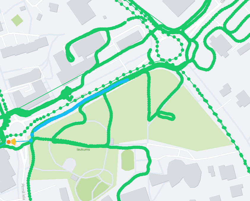
For example, here I have filtered for sequences since October 10th (2 months) - and this area shows as a mission.
If I capture images in a mission area without going through “Start capture” from the mission view, is that counted towards the mission?
If multiple users take images in a mission area, what happens?
When could Android app get this feature?
Missions in the website view?
Mission details usually (always?) show street name. Is it connected to the mission in any way, or is it just a “name” for it? Or to put it differently, is the named street preferred / counted differently?
The mission view shows “nn km road”. Is this all roads inside the mission area? How is this calculated - is it from OSM data? If so, which highway=* types are included, what other tags affect it (perhaps access=* etc)?
The goals seem to be rather on the high end - the example area above states that 513 new images are required. How is this number determined?
Well, checking several missions, it seems to be one image every 10 metres for all the found roads, that question seems to be answered
The distance in the mission detail - is this somehow related to the mission contents? As in, any requirement for the covered distance in new uploads?
Seeing a mission like this. No OSM-mapped roads. How so?
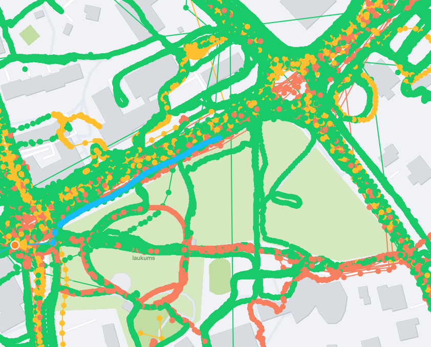
Currently the mission view is separate from the map view - this does not allow to see existing image captures together with the mission view. Would be neat to have them together as toggles, to see which exact areas would be more useful to capture inside the mission area. And perhaps the existing imagery age cutoff slider could be added…
If the documentation is expanded to explain the questions above, it would be great to include it in the app (I use some devices where there is no internet connection on the move).
The possibility hinted in the blog, “community to “turn on” mission cells. Possibly via an API or integrating with existing OSM task tools” seems extremely intriguing. I’ve wanted something like that for quite some time from JOSM - exposing that via the API sounds wonderful. Such requests might have to be constrained to smaller areas though, and perhaps even to specific spots and directions (to see some street signs).
Missions are generated based on the s2 cell overlapping any of: an area of interest where POIs are clustered already, a landuse=retail polygon on OSM, or a public_transport=station node on OSM.
Images are not counted if you do not enter Mission capture mode. If you select one Mission and capture, then move to another mission, you are still in Mission mode so all capture will be counted. But not from regular capture mode.
Each user gets credit for their own images. For competitive purposes in the future, multiple users would each get credit for completing the mission, and have +1 on their scoreboard (working on this). There is no unique point for getting it first, instead all users can complete the mission independently.
We are looking into a release date, next year of course.
We are thinking about how and where to show this on the website. Suggestions welcome!
The streetname is just the name of the mission, to give it an easy mental reference. It is chosen at random as a street inside it. In some cases, there is not a named street and it ends up with No Name, or the OSM data suggests something odd like a number. Feedback welcome on this.
The length of OSM ways in the area is calculated, anything walkable, driveable, cyclable. Does not exclude anything but we are considering excluding motorways, and checking for private tags, other logical things. For now it should be completable even skipping private ways and other hard to reach or off limits ways, based on the ratio of images required.
Currently the goal number of images is just the total meters distance of roads divided by 10. 1 image per 10 meters. We are thinking on how to calculate a more comprehensive measure of the imagery covering the lay of the land, but it is computationally intensive and could affect performance in a live view.
There is not a hard requirement for covered distance, but we generally assume covered distance will end up similar to this.
Your last mission likely has a bit of road in the corner, plus the railway could be erroneously counted as capturable. I would be curious if you can report the task ID and we can check it out. We are eager to adjust on feedback like this!
Correction: the app will not show these as completed (working on how we might be able to do this). However, I am also working on how to display a leaderboard, and the leaderboard would indeed count the images captured in a mission as counting toward completing that mission.
would be nice, if content could be uploaded over the Webuploader as well to the mission.
Currently you can do it only over the mobile device and we are not able to upload any content we capture with a other device
Thank you for all the detail, this was really helpful.
Although this does rule out most of my contributions from participating in missions.
Majority of my images come from an action camera.
Next up is a phone… but without a network connectivity, so I cannot even open those missions.
Last in the list is a phone with connectivity. But even then I usually take some quick snapshots without explicitly viewing the missions.
If a weekly batch of action camera images is a few dozen thousands of images (in summer), a thousand at most from the network-less phone, and maybe a few dozen from the connected phone.
For missions to “work” they might need to take into account all contributions, from all devices.
And for people unaware of missions, getting some notifications about completing them could be captivating
My suggestions here still stand - especially the first one.
Currently the mission view is completely disconnected. For example, the default map completely lacks highway=residential. I can switch to OSM in the explore mode, but not in the mission mode, where there are seemingly lots of dead ends and empty space with some buildings.
Having a single view with toggles, as suggested, would be much easier to use.
I couldn’t recall/find the task detail later - will see whether something similar pops up.
Although with missions not taking into account my uploads for now, I won’t be checking them very frequently
I see that some of the missions exist where I have uploaded a lot of images from an action camera in the past few weeks.
Here’s a different minor issue - this mission is not named by a road, but by a powerline, although there are enough roads in the tile. The cell ID cannot be copied, thus cannot provide it as text