Your work are impressive to, your map is almost Green and you do it alone
Yeah @pkoby you have, by far, the highest UKM of us all. You’re the best!
Something weird is happening though, I can see the exact same sequence several times on your image list. (For example, Mapillary is there 4 times.) But that doesn’t do anything to your UKMs anyway. ![]()
@eneerhut/@tao, how much GPS drift is accepted when calculating UKMs and coverage? If my GPS reception is so bad that the photos are placed 10, 20 meters away from the road, through buildings, is it than still counted? Or should I do those streets again? (Though it may be difficult always to get a good reception in between buildings.)
Also, are footpaths and cycling paths parallel to car roads counted as different roads? Are foot/cycling paths actually even counted at all?
I’m asking, because the city centre around me is covered quite well now, but it is still showing up red on my map. While an area furthest out, where I’ve only been twice, is yellow already.
I noticed that myself yesterday. A lot of my recent sequences (or the pieces cut from my larger ones into sub-1001 photo sequences) are repeated, but they weren’t uploaded more than once. I’ve seen that happen before in the last few weeks, and it always fixes itself…
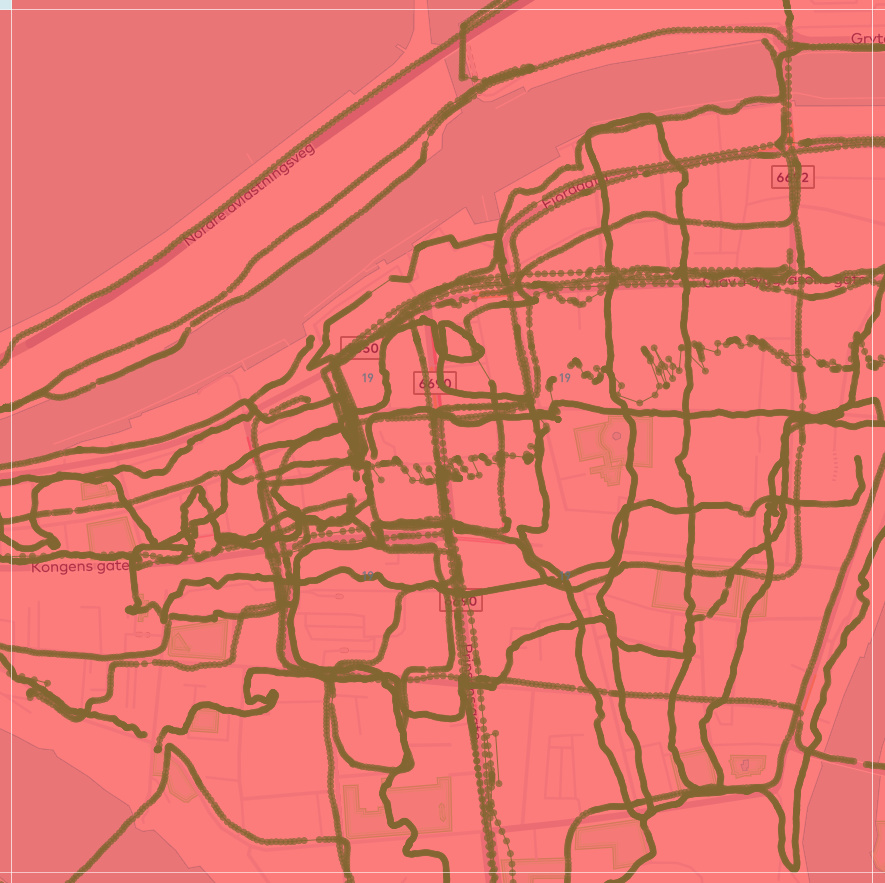
Does anybody understand why this square is still red? That would mean only 1 in 5 roads (less than 20%) has been covered. Well, I haven’t covered every single road yet, but I think it’s more like 1 in 5 is NOT covered…
For comparison, this one is considered much better covered???
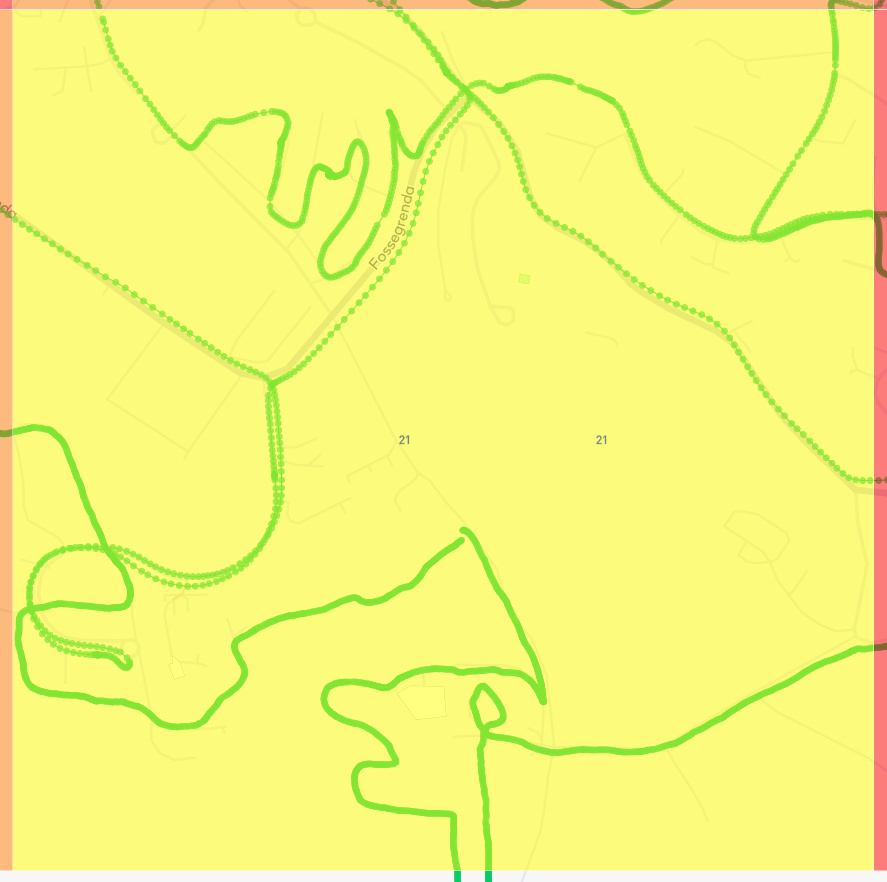
I’m beginning to think footways might count, even though I’m been basing my routes off of what I can see on the grid maps… My central square is still orange, even though I’ve covered every road, but it’s also pretty much the only square in the grid that has extensive footways (I’m adding them working outward from my location). Does the red square have many footways versus the yellow one? The yellow one looks more rural/suburban, so there might not be so much infrastructure.
@eneerhut: Just to clarify, is the participant score going to be separated per individual grid during this challenge, and if so, will it show in the leaderboard? Because I haven’t seen any change in the last few days.
1 Like
@eneerhut Is there anyway to download a GPX in mapillary tasker which reflects the bounding box (or all segments) of the area affected by the task, loading this then into i.e. OsmAnd could easily help to stay focused on the tasked area.
@pbb I will need to get @tao to chime in on the exact tolerance for map-matching.
I can say that footpaths and cycling paths are included in the total KM count for each grid and effect the colour shown for each zone.
@pbb number 19 is a strange one. There are some service roads and minor paths that have not been mapped, but I agree that it looks like well above 50% coverage. This might be where @tao’s answer on map matching will shed some light.
@tommy will it help if I send you the GeoJSON of your grid? Just let me know the area.
I’ve always expected on footpaths also counting. I’m using OpenRouteService set to foot routing to plan my mapping routes (by bicycle). The background map of the competition grid is just a standard Mapbox map, I don’t expect that to be linked to the way the scoring is calculated.
Actually, I’d say the red squace (city centre) has LESS footways than the yellow one (suburban), at least in kms. There are lots of short footpaths going through grass fields and small parks.
That is very easy to do in JOSM. Open JOSM and don’t download anything from OpenStreetmap, but open a background layer to draw over. Then start a new data layer (File > New Layer), and draw your square guided by the background layer. Then export it as GPX (File > Export to GPX). Voila!
(And you’re right, it is very helpful to have this square in OsmAnd, in the beginning I’ve been going quite a lot outside because I wasn’t aware exactly where the border was…)
One possible challenging situation I was thinking about might be a car road flanked by foot- or bicycle paths on both sides. Even if there is a big tolerance for GPS drift, then those parallel paths might always be closer to the recorded track, and none ever being matched to the central car road.
@eneerhut thanks for the offer, but I manage to create it manually. I just was thinking about that it would be a nice feature to have in tasker, but not too complicated (with a lot of dependencies in coding), since the coordinates of the grid or the shape of the area are already known to tasker. - so you don’t have to manually creating it with “approx.” coordinates.
@pbb I did it similar mainly tried to create a bounding box by manually looking at the 4 edges and then copied those in an existing gpx file.
One other question, where I did not find an answer in the forum, yet. the mapillary python tools I was able to get running two weeks ago, but:
Are the tools able to read sub-seconds?
Is it possible to interpolate the picture’s gpx coordinates between two others? i.e. you take pictures every 0.5s , but your gpx tracks has trackpoints only every 1s.
I haven’t tried it yet, but I’ve heard both ExifTool and JOSM can geotag photos with subsecond timestamps from GPX tracks.
Last Friday, the scoreboard showed me with 179 UKM and ca 74k photos. On Saturday I cycled 60km, taking ca 20k photos. I planned my route to cover as much as possible roads that I had not passed before. I have no exact number, but at least 75% of those 60km should have been new.
Now, Monday afternoon, the scoreboard counts all my new photos (96k), but the UKM has only increased with 20 to 199 UKM. I have most definitely covered more than 20km of new roads! Looking at the map, I can’t see there was much GPS drift either (less than 5m).
Unless the UKM measurement is seriously delayed, there is something very weird going on here. ![]()
The leaderboard once again didn’t update overnight (even after a hard refresh). @eneerhut I still haven’t heard from you about fixing the scoring (re: reply 78). Is something being implemented to fix the error, or did the leaderboard just not change today?
If the latter, will something be done to fix the scores before the end of the month?
There is definitely a long delay in updating of the scoreboard, and even then it seems partial. My last contribution was 60km cycling on Saturday, and today (Tuesday) afternoon, 9 UKMs were added to my score. I’m still waiting for some 20 UKM more…
Currently, we search for road segments within 50 meters of a GPS point, which means if the image position falls within drift within 50 meters of the road, it still possible to find the right road match.
All routable roads are counted as roads in UKM, including footpaths and cycling paths. For those who are interested, we are using GitHub - valhalla/valhalla: Open Source Routing Engine for OpenStreetMap to generate the road network for UKM.