A lot of postboxes have been abolished since the pictures were taken.
1 Like
Thanks for the detailed analysis.
-
The workflow is a bit clunky here. You can load the Mapillary image layer in iD editor and get an idea of which image the feature may have been detected in, but the easiest way to tell would be to look directly on Mapillary.com with the same point feature layer enabled.
-
That doesn’t sound right. Can you share a screenshot indicating what you mean?
-
Was there any imagery in that area? Do you have an example of a mailbox that should have been detected but wasn’t?
4 & 5. It sounds like we should set up a verification project for mailboxes in Antwerp to improve results.
Mailbox is the term the vision team came up with so I’ll check with them on the naming convention. There might be some deliberate ambiguity here ![]()
On point C. The dots in each GeoJSON are the estimated lat/lon of the objects. The GPS accuracy of the capture device is one of the variables that goes into this.
250 local items ![]()
amenity=bench
IF I OLREDY HAVE about over 100500 items…

![]()
https://mapillary.github.io/mapillary_greenhouse/mapillary2osm/
What is ZERO in stat ???
P.S.
amenity=bench (KYIV)
I’m still getting input from others on how this should be mapped, but I am quite sure that this not appropriate nor is it in the spirit of mapillary2osm to simply add 250 benches at a stadium. @filipcor @nunocaldeira @Approksimator, do you have any input here?
The idea with mapillary2osm is to add map features that Mapillary has identified and that were included in the GeoJSON. Even then, we are only encouraging you to add map features that were identified correctly.
2 Likes
https://wiki.openstreetmap.org/wiki/Tag:amenity%3Dbench
Use the tag amenity=bench on a node, but not as a row of benches, doesn’t it?
250 nodes in this situation does not seem correct, but asking around to see what others think.
1 Like
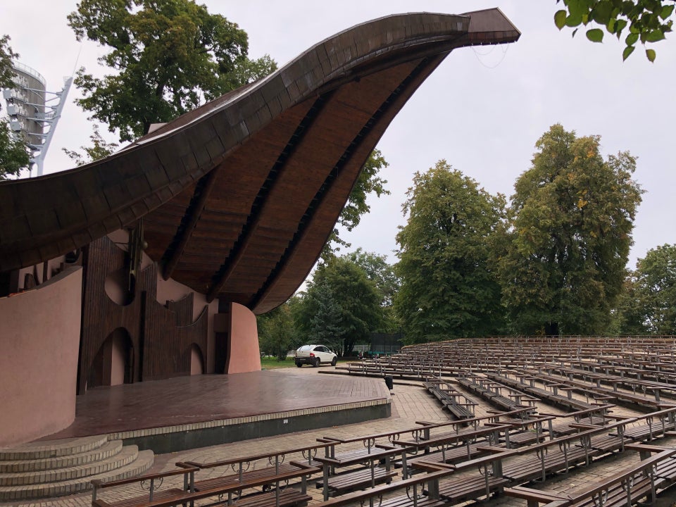
This looks to me like its a outdoor amphitheater with an outdoor seating area. I don’t believe tagging these connected benches as several hundred unique points is useful for consumers of OSM data, nor for database accuracy. I can present this to the tagging mailing list to seek a more official discussion.
2 Likes
@velmyshanovnyi It appears that almost all of your changesets were made 11 hours ago to 9 hours ago from current time of my writing. The challenge ended May 16th at the end of the day UTC, so that’s 3am in Ukraine, so it appears your edits occurred within the UTC time window. You seem to have tagged many other changesets with #mapillary2osm that included none of the features here, and instead adjusted roads, added milestones, etc. These of course can’t be counted. So here I have your final score:

I also see you added a changest 22 days ago with the challenge hashtag and noted added a post box, but the actual node you added there was a post office (which is a building and not the box). So this of course is not counted as that’s a different POI.
For the benches, you can see here on OSM that only a few of what you added can be rendered, because it’s too dense:

From satellite, it’s very clear that these are not benches, this is stadium seating.

This changest would likely be reverted by an OSM user doing validation, and I’ll seek confirmation.
These also are not visible on any Mapillary photos nearby that I can see:

So it appears these would not have been added using the Mapillary data provided, nor Mapillary imagery as reference. In this case you’re clearly adding data outside the scope of the challenge, with no photo evidence, and no relation to Mapillary, which is not fair to other participants who have put in the hard work of referencing the Mapillary data and imagery to create data.
I do not see the amphitheater seating as complying with the intention of what a bench is according to the OSM wiki: Tag:amenity=bench - OpenStreetMap Wiki
If you can make a good case for why:
a) these benches are legitimate OSM data, despite not being individual park benches or what typically is considered a bench
b) these are legitimate data based on any existing OSM examples that make a similar use
c) these are legitimately tagged changesets with #mapillary2osm considering that the “mapillary” part of that changeset has no relation to the benches you added here, as they were not captured on Mapillary nor detected on Mapillary as a high number of individual benches
The effort and time you put in is commendable, but it seems clear that this was intended to be a shortcut to getting a high score rather than an effort to participate in good faith.
2 Likes


Playing devil’s advocate here:
-
Those Mapillary images you linked do show some benches, but they weren’t detected by the computer vision as benches (they show up as fence), which means they wouldn’t have been in the downloaded database of detections to add.
-
In any of those images you can only see a small subset of the total benches (maybe 8-10?), not all 250.
-
I certainly would not add these as amenity=bench nodes. If anything, I would add them as ways, given that from your supplementary images they are permanently fixed. Each row of seating could be a bench, but that once again gives you only as many as there are rows times columns (about 30?). These are akin to bleachers at sports pitches. I wouldn’t add those as nodes no bench, though you could argue that they could be tagged as the latter.
(I remembered I have mapped an outdoor amphitheatre with benches, and looking back at it, I did indeed use ways, which do not render in Mapnik: OpenStreetMap. To be fair, though, these are much less obviously bench-like: https://media-cdn.tripadvisor.com/media/photo-s/0a/89/f2/10/amphitheater.jpg, and could be tagged as barrier=retaining_wall just as well.)

I see that it’s true that these are indeed benches,by structure (with separators). But so far the consensus from OSM US is that this should be tagged as an area: Tag:leisure=bleachers - OpenStreetMap Wiki
The separators exist but is it really a different bench structure on the other side of the separator, where seats continue?
Anyway, this should be a local decision for OSM Ukraine, the other communities can only suggest a perspective.
Also, tagging benches in the image does not train the Mapillary computer vision algorithm at this time, it simply stores the tags for later searching.
PLS add Billboard detection
I’m manually added over 1k Billboard to OSM (50cm…120cm accuracy)
In the near future I will try to process more than 50,000 exact coordinates
I can provide a list of exact coordinates (as yet this one thousand) to study the system
1 Like
Dear Edoardo,
Replies with screenshots made a huge post, have sent as text-RTF + pics-PDF to support@maply for your attention. Any further questions please ask.
Best, K.
2 Likes

Responded. Thanks.
1 Like
I don’t understand the question you are asking here.
1 Like
The whole focus of mapillary2osm was to take map features that Mapillary had detected and add them to OpenStreetMap if they were in fact correctly identified.
@velmyshanovnyi I thought this was pretty clear in the instructions. As Chris said OSMUS was pretty clear on the consensus that these should not be added as individual nodes. The international community had the same response as well.
2 Likes
@eneerhut, when will the official results of this experiment/challenge?
1 Like